Wednesday, June 29, 2005
Sentier du Facteur

The Sentier du Facteur (Postman's Track) was carved out of the cliff in the middle ages by farmers from the Abbaye des Ayes. It starts from the plateau by the L'Huis (door) which has become Luisset. The area is widely used by climbers due to the many fissures and cracks in the rock.

Parking at the Pont du Bernin carry along the route national to a raised section (gendarme couché), cross the road and follow the tracks that lead up to a reservoir then the Crapanoz bridge. Continue up the Chemin des Communaux which turns into a steep track. This joins the road that leads to the plateau des Petites Roches at la Fontaine. Climb the road through four hairpins and a long, but lit, tunnel. 1km after the tunnel take the footpath at les Meunière, this is steep and crossed the footbridge of la Gorgette before climbing and joining a track. Follow the cliffs around until a signpost to the Sentier du Facteur points to a track down to the right. This leads through a rock door - the Huis and then onto a very exposed and rocky track.

The Sentier du Facteur is close to the limit what is possible to descend on a mountainbike. The start is on a narrow and rocky path. Take care with pedals as these can catch rocks which may destabilize the rider. The cliffs are steep and a fall would have serious consequences. The first part of the track passed through the climber's area, take care about climbers dislodging rocks or falling! After 3 hairpins it enters woods which are much less exposed. Around half distance it is possible to look at the waterfalls.
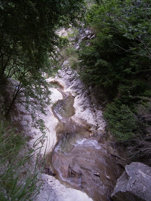
The hardest section occurs around two-thirds distance. The path is covered with small rocks, then becomes very steep with a series of rock steps. This section lasts about 200 meters. Afterwards the gradient is much friendlier. It rejoins the Crapanoz route by a large concrete water tank.

Tuesday, June 28, 2005
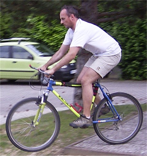
Shimano PD-M520 SPD Pedal
I'd resisted getting automatic pedals from my Mountain Bike for some time however after rats (yes!) ate my Look cycling shoes I decided to upgrade both my road bike and mountain bike pedals at the same time. The natural choice was to fit the same pedals to both. The Shimano SPD M520 "Spud" pedal is the bottom of the range automatic pedal from Shimano but it is a good unit none-the-less. The design is over a decade old so they have ironed out the bugs. It weighs around 380grams, surprisingly this is a shade more than my old Shimano XT pedals with clips.
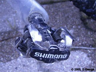
The open binding mechanism stops the pedal from getting clogged with mud and the design is cunningly weighted so the pedal always falls ready to engage with the shoe cleat. The spindle is hard wearing chrome-moly fitted with a low maintenance sealed bearing cartridge axle. The cleat tension is adjustable.
It is suprisingly easy to get feet in and out of the pedal but the pedals take a little getting used to, the foot is held securely and initially it is hard to get feet out in time when confronted by obstacles.
The pedal retails at 29 Euros or around $40. Decathlon stock their own brand copy for 25 Euros.
Buy from BikePartsUSA
Sunday, June 26, 2005
Traverse of the Brame Farine
The Brame Farine is a large mountain at the northern end of the Gresivaudan valley between Pontcharra and Allevard. This route is largely over forest tracks of moderate gradient but it is quite long. The single track from the Brame Farine to la Cochette runs over bedrock which can be quite slippy but this can be avoided by taking a diversion via Ste Catherine.
You can park your car at different spots: le Cheylas, le Moutaret or even at the top of the road at le Vernay to save 500 meters climbing. I parked at Morêtel in front of the town-hall. This village seems almost dead with just a couple of old people. I imagine the town-hall serves the whole district.
From Morêtel climb the route to the Charrière hairpin, their is a sign pointing to la Fontanil. Take the track which passes behind a large stone house and then descends steeply for 10 meters into a wood. Here there is a fork, take the right fork which tracks down through a wood before opening up onto a field. Keep to the left of the field and you will pick up the track near the opposite end, this leads into the village.
In the village turn right onto the minor road in the direction of l'Abbaye, after about 1km there is a sign which points in the direction of le Trouillet/L’Abbaye, take this track which rejoins the road a bit further on, cross over the road. There is a post with a black and yellow arrow, take the track leading to le Berruer (flèche noire sur jaune) and then Papillard.
Turn right onto the road. At Montaucher turn right onto a forest trail. At the ste Catherine (691 mètres) crossroads tehre is a track leading to the right which climbs to the Col de Goulet, it is mentioned in some mountain bike guides but is too steep to climb, even on feet in places! To the left the track leads down to the ancient citadel of Avalon. In the middle ages this was a walled town with a castle. Some parts remain in the buildings.
After about 7km of rolling track the route rejoins a main road, turn right to le Moutaret. Cross the village. There is a fountain in front of the church if you want to refill your drinks bottle. I've drunk from here with no ill effects. At the far end of the village take a right hand hairpin that climbs to the Fontanettes. After about 1km the road turns into a track with a gate to stop motor vehicles. The track climbs fairly evenly with paths leading to the left and right, always keep straight on except for an obvious fork later on where you should take the left track. Eventually you arrive at a spot known as the Crêt Brûlé from here you can see the Telecommunications Tower, a landmark clearly visible from the valley. At the Col du Goulet (sign and road that leads to the tower), take the right and 1km later take the Brame Farine road on the right. The top of the hill is, somewhat illogically, the muddiest part of the whole route and should be avoided immediately after heavy rain.
After 200 m there is the chalet de Brame Farine on a right hand hairpin, a sign indicated the orientation table straight ahead. This track is muddy but it is possible to avoid the worst with care. It rolls along the top of the ridge.
Teh orientation table dates from 1914 and very dissapointingly trees have grown all around so their is no view. A narrow and very steep track descends to the ruined barns at la Cochette. It is easy to skid both wheels on this track!
At la Cochette turn right and follow the track, then road past le Vernay to the Charrière crossroads. Turn onto the track to the house once again but this time turn left and follow the tracks that run close to the road we climbed on.
At les Mailles take the old railway track of the "Tacot" (chuff-chuff) to the village of le Cheylas (yellow markings, at one point it passes just to the right of a chalet style house). Turn left onto the D78 to Morêtel.

Location: Belledonne, Isère department
Climbing: 1951m
Descent: 1951m
Distance: 41km
Time: 4h30
More Information Brame Farine par la route forestière de Montaucher
Tuesday, June 21, 2005
Traverse of the Oisans - World Cup Event
"La traversée de l'Oisans" UCI World Mountainbike Cup Event will be held on the 7th of August 2005. It features three races and two different routes over the best trails that the Oisans mountain range has to offer including the renowned plateau d'Emparis. All this with the splendid glaciers and peaks of the Ecrins mountains as backdrop.

The 100km event starts at Les Deux Alpes, taking in the ski resort of l'alpe d'Huez by way of the Plateau d'Emparis, Auris en Oisans, Huez and Vaujany to finish at Bourg d'Oisans. Riders climb over 4100 vertical meters. A 50km time trial and tour climb 1400 meters, passing through Huez village to finish at Bourg.
More info Bike Oisans
Val Thorens Mountain Bike Trophy
The Val Thorens Mountain Bike Trophy will be run on Sunday 31st July 2005. This is a cross-country race at the ski resort of Val Thorens and features two climbs over 3,000 meters (about 10,000'). The "Black" pro circuit is 105km with 3,905 meters of climbing through alpine pastures towards the snow covered glacier du Peclet. The "red" circuit is 70km and aimed at pro-women and senior men. It has 2750 meters of climbing. There is also an easier "blue" route without the climb to 3000 meters and kids and family rides.
More info: Val Thoren's Mountain Bike
More info: Val Thoren's Mountain Bike
Sunday, June 19, 2005
Chateau Montfort
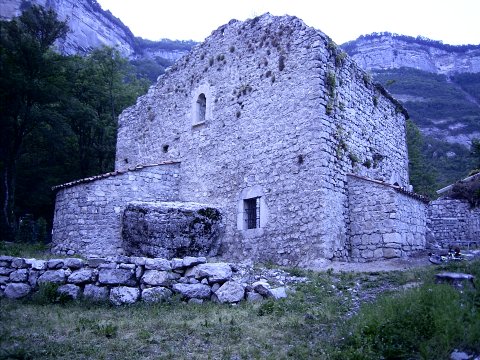
The Chateau Montfort (or Robert) comes at the end of the Coteau des Crolles mountain bike trail. The first mention of fortifications on the site comes from a property register for village of Domène dating from 1069 - it mentions Montis Fortis. It was probably a large mound with a wooden tower erected on a promontory dominating this part of the Gresivaudan. The stone castle dates back to the 13th Century probably following the construction of a stone tower a century earlier.

During the middle ages this was part of the marches between the Dauphiné and the Savoie. Montfort formed part of a defensive chain of at least ten castles and numerous fortified residences. The Chateau de Montfort served three functions, a lookout and defence for the valley, it blocked the Pas de la Ferté (Pal de Fer) a key access to the Plateau des Petites Roches and was a residence.

When the Dauphine Béatrix de Faucigny, daughter of Pierre Count of the Savoie and wife to the Dauphin Guigues VII, lived at Montfort in 1286 the chateau had an outer circumference of 47 toises (1 toise is about 2 meters). The interior had a quadrangular shaped tower on four stories of about 28 meters height. There were two halls one of which was heated by a large fire, living quarters and a kitchen. The entrance to the caste was defended by a gate defended by a guardhouse.

Apart from the guardhouse only the lower walls of the castle remain. The guardhouse was still occupied into the 20th century.
The site was largely overgrown until 1999 when an association (les Raissoneurs de Pierre) agreed to restore and make safe the ruins. Volunteers spend each Satuarday working on the remains. A fortnight of work is planned between the 11th and 22nd of July, 2005. This will complete archaeological exploration of the site. If you are interested in working on a real French castle telephone: 04 76 08 99 20. For logistical reasons you will need to be available for 1 week between 9h30 and 17h00.

The Manival Gorge from le Sappey-en-Chartreuse
The Gorges du Manival are a classic Mountain Bike (VTT) descent into the Gresivaudan valley. I had not been this way since 1991 so it was time for a return. I'd mentioned the route to one of the up and coming young Grenoble VTTists who whisted through his teeth and said "dur, dur les Gorges". In fact they are not quite as bad as all that but still deserve respect.
However I'm getting ahead of myself. I decided to profit from a father's day lunch at the Café des Alpes and got Gigi to put my trusty mountain bike on her roof-rack. That saved me the hot and long climb through la Tronche to le Sappey. Instead from le Sappey I took the road that leads to the Pre de l'Essart. This is the same track used by cross-country skiers during the winter months. At about 3km there is a fork in the road - it is possible to take the right fork which leads up to the Pas de la Branche, the gradient is okay but the track is very muddy for quite some time after rain. Chartreuse mud deserves respect, it is like glue and a devil to wash off. Instead continue up to a cross roads, take the left turn (there is a yellow arrow symbol on a post) as the right turn is too steep to cycle. After a few hundred meters you join a good track that leads from le Churut to the Col de l'Emeindras, turn right and continue up this road. The tracks are steep in places but can be cycled without any carrying.

At the col you have a view on the backside of Chamchaude - a classic ski touring destination, it must be the worlds most skied mountain without lifts. There is also a the ruins of a chalet - Emeindras de Dessus. In the autumn of '91 and old man explained that they'd built the chalet there because there had never been any avalanche in the area, sure enough the following winter the chalet was destroyed by a slide. I don't know if this is true but knowing the ways of avalanches it is quite possible.
From here turn right to continue following a well made track. It is possible to cross directly over the Col de l'Emeindras (1372 meters) and then follow a track on the other side to rejoin the GR9, but the track is very muddy and not worth the candle, either on foot or bike. Instead climb to the little farm of Emeindras de Dessus and keep going north east across the field to a gate and the start of the track that descends to the Col du Coq. The alternative is to climb to the top of the hill behind the farm to follow the GR9 walking trail to the Col de la Faita. The track rejoins the road just below the ex-ski station of the Col du Coq. Descend the road to the entrance of the hamlet of le Baure (hairpin left) and take the footpath to the Col du Baure, this is pretty much the only carrying of the day. You may also be able to descend to the Col du Baure directly from the Col du Coq but I've not attempted this - it would complete an nice off-road outing.

Now things get interesting, the descent into the Gorges du Manival is on a narrow singletrack with around 20 hairpin bends. The track is not steep but the hairpins are tight and the route is very exposed. Make a mistake and you slide a long way. This section should only be attempted on a good mountainbike. That said, it is a very pleasant run down to the bottom of the Gorges. There is a small hut but only a vandalized annex is open for public use. Here the track widens into a jeep trail. After some 2km follow a track to the left (signpost) the Fontaine Bonnet parking. Cross the road with a dog leg to the right to pick up a track that leads down to the Baraque du Clot du Bert.
Climbing: 885m
Descent: 1530m
Distance: 21km
Time: 2h30
However I'm getting ahead of myself. I decided to profit from a father's day lunch at the Café des Alpes and got Gigi to put my trusty mountain bike on her roof-rack. That saved me the hot and long climb through la Tronche to le Sappey. Instead from le Sappey I took the road that leads to the Pre de l'Essart. This is the same track used by cross-country skiers during the winter months. At about 3km there is a fork in the road - it is possible to take the right fork which leads up to the Pas de la Branche, the gradient is okay but the track is very muddy for quite some time after rain. Chartreuse mud deserves respect, it is like glue and a devil to wash off. Instead continue up to a cross roads, take the left turn (there is a yellow arrow symbol on a post) as the right turn is too steep to cycle. After a few hundred meters you join a good track that leads from le Churut to the Col de l'Emeindras, turn right and continue up this road. The tracks are steep in places but can be cycled without any carrying.
At the col you have a view on the backside of Chamchaude - a classic ski touring destination, it must be the worlds most skied mountain without lifts. There is also a the ruins of a chalet - Emeindras de Dessus. In the autumn of '91 and old man explained that they'd built the chalet there because there had never been any avalanche in the area, sure enough the following winter the chalet was destroyed by a slide. I don't know if this is true but knowing the ways of avalanches it is quite possible.
From here turn right to continue following a well made track. It is possible to cross directly over the Col de l'Emeindras (1372 meters) and then follow a track on the other side to rejoin the GR9, but the track is very muddy and not worth the candle, either on foot or bike. Instead climb to the little farm of Emeindras de Dessus and keep going north east across the field to a gate and the start of the track that descends to the Col du Coq. The alternative is to climb to the top of the hill behind the farm to follow the GR9 walking trail to the Col de la Faita. The track rejoins the road just below the ex-ski station of the Col du Coq. Descend the road to the entrance of the hamlet of le Baure (hairpin left) and take the footpath to the Col du Baure, this is pretty much the only carrying of the day. You may also be able to descend to the Col du Baure directly from the Col du Coq but I've not attempted this - it would complete an nice off-road outing.

Now things get interesting, the descent into the Gorges du Manival is on a narrow singletrack with around 20 hairpin bends. The track is not steep but the hairpins are tight and the route is very exposed. Make a mistake and you slide a long way. This section should only be attempted on a good mountainbike. That said, it is a very pleasant run down to the bottom of the Gorges. There is a small hut but only a vandalized annex is open for public use. Here the track widens into a jeep trail. After some 2km follow a track to the left (signpost) the Fontaine Bonnet parking. Cross the road with a dog leg to the right to pick up a track that leads down to the Baraque du Clot du Bert.
Climbing: 885m
Descent: 1530m
Distance: 21km
Time: 2h30
Saturday, June 18, 2005
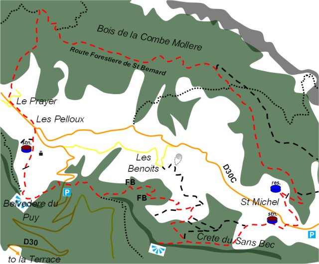
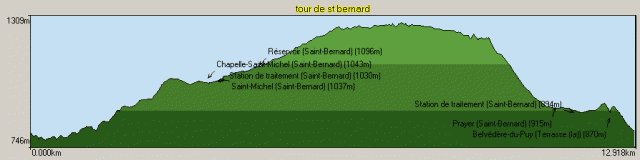
Tour of St Bernard en Chartreuse
St Bernard groups the communities on the northern end of the Petites Roches plateau. This mountain bike tour takes in most of the area over 800 meters of climbing and 13km on tracks and forest roads.
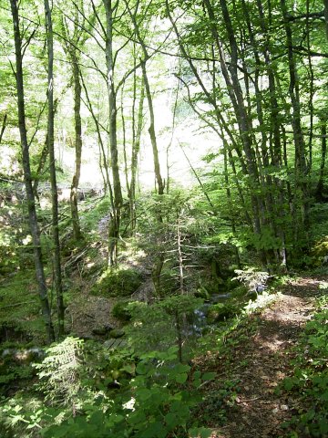
Park your car (or cycle) to the Enversin crossroad's on the road above la Terrace. This is at 800 meters but, like much in the Chartreuse, seems to have escaped the cartographers at the IGN. It is basically the point where the Petites Roches walking tour crosses the road. Take the track that heads towards the Carrefour (crossroads) Barbousse (there is a sign on the left side of the road looking up the hill). You are on a single track that leads through a fairly open forest. At the crossroads (690 meters) take the left fork which is singposted les Benoits. The track continues more or less on the contour but you may need to carry your bike on some of the steeper sections. In all there is about 20 minutes of portage to the Col de Marcieu in total. Eventually you cross a small brook by way of a wooden bridge, the path then zig-zags up the side of the valley before following the brook on its right bank. Eventually it joins an unmetalled road. This leads to the hamlet of les Benoits and our track is signposted by a small yellow arrow on a post.

Turn left onto the track, after a couple of hundred yards of flat riding and before a left hand hairpin there is a right turn, this leads up to the Crete de Sans Bec. Take this, the climb up to the crete is steep but a couple of tracks to the left save some meters of climbing. The track leads to the hamlet of St Michel, turn right for 100 meters onto the departmental road then left onto the Route Forestiere de St Bernard, this is right before the Col de Marcieu ski station. About 5km from the main road the track peters out, straight on is a single track, this leads to the route forestiere de la Herse and eventually the Sanatorium of the Petites Roches. Our track descends steeply on the left bank of the Bruyant stream to la Prayer eventually joining a metalled road at the entrance to the village.

At le Prayer turn left onto the departmental for about 500 meters. Just at the exit of the village there is a brown wooden chalet and the church of le Pelloux is clearly visible across the fields. Take the track to the right, keep to the left of the water treatment works. The track crosses a style and then disappears, keep as high as possible and traverse point 936meters on the IGN map to reach the Belvedere du Puy there is a viewing platform to look at the Belledonne mountains. The singletrack rejoins l'Enversin, it is quite steep but is all rideable without too much technique. The end of the track is overgrown and take care rejoining the road as it is steep.
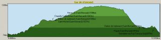
Location: Chartreuse, Isère department
Climbing: 809m
Descent: 809m
Distance: 13km
Time: 2h30
More Information: Tour de St Bernard depuis le carrefour de l'Enversin
Park your car (or cycle) to the Enversin crossroad's on the road above la Terrace. This is at 800 meters but, like much in the Chartreuse, seems to have escaped the cartographers at the IGN. It is basically the point where the Petites Roches walking tour crosses the road. Take the track that heads towards the Carrefour (crossroads) Barbousse (there is a sign on the left side of the road looking up the hill). You are on a single track that leads through a fairly open forest. At the crossroads (690 meters) take the left fork which is singposted les Benoits. The track continues more or less on the contour but you may need to carry your bike on some of the steeper sections. In all there is about 20 minutes of portage to the Col de Marcieu in total. Eventually you cross a small brook by way of a wooden bridge, the path then zig-zags up the side of the valley before following the brook on its right bank. Eventually it joins an unmetalled road. This leads to the hamlet of les Benoits and our track is signposted by a small yellow arrow on a post.
Turn left onto the track, after a couple of hundred yards of flat riding and before a left hand hairpin there is a right turn, this leads up to the Crete de Sans Bec. Take this, the climb up to the crete is steep but a couple of tracks to the left save some meters of climbing. The track leads to the hamlet of St Michel, turn right for 100 meters onto the departmental road then left onto the Route Forestiere de St Bernard, this is right before the Col de Marcieu ski station. About 5km from the main road the track peters out, straight on is a single track, this leads to the route forestiere de la Herse and eventually the Sanatorium of the Petites Roches. Our track descends steeply on the left bank of the Bruyant stream to la Prayer eventually joining a metalled road at the entrance to the village.
At le Prayer turn left onto the departmental for about 500 meters. Just at the exit of the village there is a brown wooden chalet and the church of le Pelloux is clearly visible across the fields. Take the track to the right, keep to the left of the water treatment works. The track crosses a style and then disappears, keep as high as possible and traverse point 936meters on the IGN map to reach the Belvedere du Puy there is a viewing platform to look at the Belledonne mountains. The singletrack rejoins l'Enversin, it is quite steep but is all rideable without too much technique. The end of the track is overgrown and take care rejoining the road as it is steep.
Location: Chartreuse, Isère department
Climbing: 809m
Descent: 809m
Distance: 13km
Time: 2h30
More Information: Tour de St Bernard depuis le carrefour de l'Enversin
Friday, June 17, 2005
Seuil Loop
The micro ski station of the Col du Marcieu looks like a good starting point for a number of routes. Unfortunately the track just after the resort on the left crosses a private hunting ground with lots of warning signs. Knowing French hunter's penchant for shooting anything that moves I decided not to explore futher in this direction.
The Seuil Loop starts fromt the carpark at the Col de Marcieu and heads in the direction of the St Bernard reservoir, intially crossing the hamlet of St Michel on a dirt road. After a couple of switchbacks a path climbs to the right (1km), don't follow this but continue straight on. At 3km the track crosses the walking path of the Tour des Petites Roches, this is a bit steep. Keep going another 500 meters and a forest road leads off to the right, take this and you immediately backtrack on a route that more or less follows the contour of the slope. The track can be muddy in or immediately after wet weather (damn Chartreuse mud!). The track drops down to the top of the Marcieu drag lifts. Just after take a track that leads down to the right, turn left ignoring the track that leads back to the pistes. You now join a nice singletrack. There are some technical bits but nothing that should force a moderate rider to dismount. The track crosses the ski pistes to rejoin the road above St Michel.
Climbing: 337m
Descent: 337m
Distance: 6.6km
Time: 1h00
Route on Bivouak.net:
Boucle du Seuil
Wednesday, June 08, 2005
Mégavalanche 2005 - l'Alpe d'Huez
The Mégavalanche held in the ski resort of l'Alpe d'Huez (Isère) offers two marathon descents through the stunning mountains of the Grandes Rousses with a qualifying race on Saturday 30th July and the Mégavalanche the following day.
Open to Pros and Amateurs alike the Mégavalanche is the longest, hardest and most spectacular mountain bike descent in the world. The mixed course, starting from the top of the 3323 meter Glacier de Sarenne puts cross-country and downhill specialists on level pegging. The route is some 30km over 2800 negative meters, from the Pic du Lac Blanc (3323m) to the village of Allemont (720 mètres), a mixture of ice, snow, high mountain tracks, pastures and forest single track.
More info: Megavalanche
Tuesday, June 07, 2005
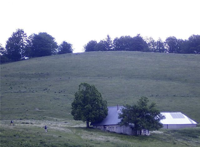
My Bike: A Raleigh Dynatech, circa 1989 equipped with Shimano Deore XT groupset, Suntour Chainset and Manitou fork. Weight about 11.5kg

Coteau des Crolles
This mountain bike route is in the Chartreuse Regional Park behind the small town of Crolles about 20km north of Grenoble. It forms a dumbell. Starting from the Montford Funiculair Railway ride into the little housing estate of Le Coteau, pick up the Chemin de Chateau that passes between houses. Most of the route is marked by yellow stripes. This zig-zags up to a level path, turn left following the contour of the mountain to the Tamoux, here the road hairpins to the right but you can cut a corner by following a singletrack straight on. Follow the track the Platre Magny - you can climb to the Crolles Waterfall although these usually only flow in spring. It is best to cross over a small bridge here and climb some stairs to the road.
Continue in the direction of Craponoz but rather than descend to Craponoz take a right turn at the junction to climb to a wood knows as les Gros Chenes (the big oaks) you eventuall reach the highpoint of the route at 444 meters. Here the unmetalled road turns into a singletrack with a couple of stairs which the more technically proficient may be able to take on their bikes. You eventually rejoin the route to Platre-Magny. Here you descend the metalled road about 50 meters passed a big white house on the right, the path is on the left crossing over the stream. At Tamoux it is better to stay on the road than to try and reclimb the singletrack. Finally at Le Coteau follow the Chemin des Chateaux. You will come across the XIIIth century fortress of Chateau Robert. This formed a frontier post between the Kingdom of Savoie and the Dauphiné. It is ruined but largely intact. The descent from the Chateau is very steep, pass behind a reservoir building to rejoin the funiculair.
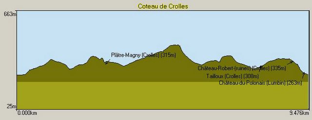
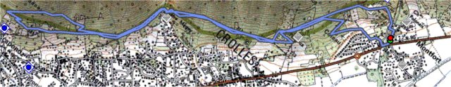
Parking: Montfort Funiculaire - watch out for thieves, do not leave anything in the car.
Mountain Range : Chartreuse, France
Map : Carte IGN TOP 25 3334 OT Chartreuse Sud
Bivouak.net: Coteau des Crolles
Continue in the direction of Craponoz but rather than descend to Craponoz take a right turn at the junction to climb to a wood knows as les Gros Chenes (the big oaks) you eventuall reach the highpoint of the route at 444 meters. Here the unmetalled road turns into a singletrack with a couple of stairs which the more technically proficient may be able to take on their bikes. You eventually rejoin the route to Platre-Magny. Here you descend the metalled road about 50 meters passed a big white house on the right, the path is on the left crossing over the stream. At Tamoux it is better to stay on the road than to try and reclimb the singletrack. Finally at Le Coteau follow the Chemin des Chateaux. You will come across the XIIIth century fortress of Chateau Robert. This formed a frontier post between the Kingdom of Savoie and the Dauphiné. It is ruined but largely intact. The descent from the Chateau is very steep, pass behind a reservoir building to rejoin the funiculair.
Parking: Montfort Funiculaire - watch out for thieves, do not leave anything in the car.
Mountain Range : Chartreuse, France
Map : Carte IGN TOP 25 3334 OT Chartreuse Sud
Bivouak.net: Coteau des Crolles
![]()
 MyYahoo