Saturday, June 18, 2005
Tour of St Bernard en Chartreuse
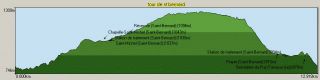
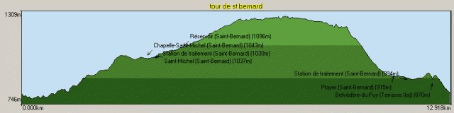
St Bernard groups the communities on the northern end of the Petites Roches plateau. This mountain bike tour takes in most of the area over 800 meters of climbing and 13km on tracks and forest roads.
Park your car (or cycle) to the Enversin crossroad's on the road above la Terrace. This is at 800 meters but, like much in the Chartreuse, seems to have escaped the cartographers at the IGN. It is basically the point where the Petites Roches walking tour crosses the road. Take the track that heads towards the Carrefour (crossroads) Barbousse (there is a sign on the left side of the road looking up the hill). You are on a single track that leads through a fairly open forest. At the crossroads (690 meters) take the left fork which is singposted les Benoits. The track continues more or less on the contour but you may need to carry your bike on some of the steeper sections. In all there is about 20 minutes of portage to the Col de Marcieu in total. Eventually you cross a small brook by way of a wooden bridge, the path then zig-zags up the side of the valley before following the brook on its right bank. Eventually it joins an unmetalled road. This leads to the hamlet of les Benoits and our track is signposted by a small yellow arrow on a post.

Turn left onto the track, after a couple of hundred yards of flat riding and before a left hand hairpin there is a right turn, this leads up to the Crete de Sans Bec. Take this, the climb up to the crete is steep but a couple of tracks to the left save some meters of climbing. The track leads to the hamlet of St Michel, turn right for 100 meters onto the departmental road then left onto the Route Forestiere de St Bernard, this is right before the Col de Marcieu ski station. About 5km from the main road the track peters out, straight on is a single track, this leads to the route forestiere de la Herse and eventually the Sanatorium of the Petites Roches. Our track descends steeply on the left bank of the Bruyant stream to la Prayer eventually joining a metalled road at the entrance to the village.

At le Prayer turn left onto the departmental for about 500 meters. Just at the exit of the village there is a brown wooden chalet and the church of le Pelloux is clearly visible across the fields. Take the track to the right, keep to the left of the water treatment works. The track crosses a style and then disappears, keep as high as possible and traverse point 936meters on the IGN map to reach the Belvedere du Puy there is a viewing platform to look at the Belledonne mountains. The singletrack rejoins l'Enversin, it is quite steep but is all rideable without too much technique. The end of the track is overgrown and take care rejoining the road as it is steep.
Location: Chartreuse, Isère department
Climbing: 809m
Descent: 809m
Distance: 13km
Time: 2h30
More Information: Tour de St Bernard depuis le carrefour de l'Enversin
Park your car (or cycle) to the Enversin crossroad's on the road above la Terrace. This is at 800 meters but, like much in the Chartreuse, seems to have escaped the cartographers at the IGN. It is basically the point where the Petites Roches walking tour crosses the road. Take the track that heads towards the Carrefour (crossroads) Barbousse (there is a sign on the left side of the road looking up the hill). You are on a single track that leads through a fairly open forest. At the crossroads (690 meters) take the left fork which is singposted les Benoits. The track continues more or less on the contour but you may need to carry your bike on some of the steeper sections. In all there is about 20 minutes of portage to the Col de Marcieu in total. Eventually you cross a small brook by way of a wooden bridge, the path then zig-zags up the side of the valley before following the brook on its right bank. Eventually it joins an unmetalled road. This leads to the hamlet of les Benoits and our track is signposted by a small yellow arrow on a post.
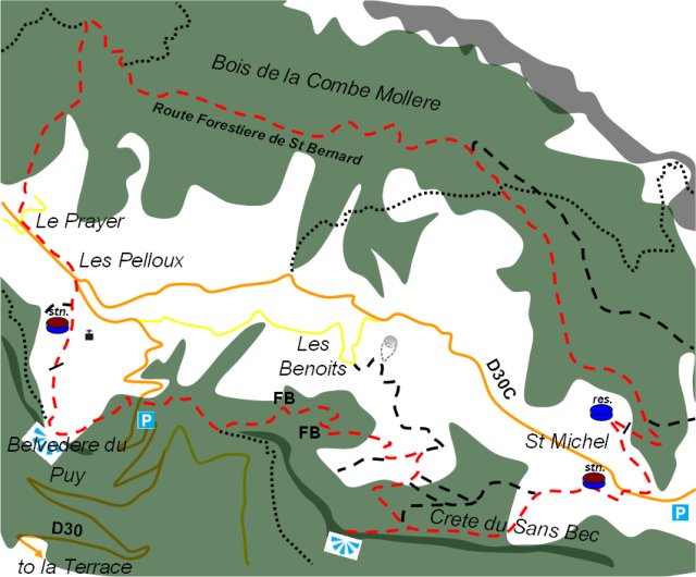
Turn left onto the track, after a couple of hundred yards of flat riding and before a left hand hairpin there is a right turn, this leads up to the Crete de Sans Bec. Take this, the climb up to the crete is steep but a couple of tracks to the left save some meters of climbing. The track leads to the hamlet of St Michel, turn right for 100 meters onto the departmental road then left onto the Route Forestiere de St Bernard, this is right before the Col de Marcieu ski station. About 5km from the main road the track peters out, straight on is a single track, this leads to the route forestiere de la Herse and eventually the Sanatorium of the Petites Roches. Our track descends steeply on the left bank of the Bruyant stream to la Prayer eventually joining a metalled road at the entrance to the village.
At le Prayer turn left onto the departmental for about 500 meters. Just at the exit of the village there is a brown wooden chalet and the church of le Pelloux is clearly visible across the fields. Take the track to the right, keep to the left of the water treatment works. The track crosses a style and then disappears, keep as high as possible and traverse point 936meters on the IGN map to reach the Belvedere du Puy there is a viewing platform to look at the Belledonne mountains. The singletrack rejoins l'Enversin, it is quite steep but is all rideable without too much technique. The end of the track is overgrown and take care rejoining the road as it is steep.
Location: Chartreuse, Isère department
Climbing: 809m
Descent: 809m
Distance: 13km
Time: 2h30
More Information: Tour de St Bernard depuis le carrefour de l'Enversin
permalink posted by davidof : 6:33 pm

![]()
 MyYahoo