Tuesday, June 07, 2005
Coteau des Crolles
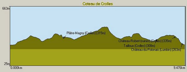
This mountain bike route is in the Chartreuse Regional Park behind the small town of Crolles about 20km north of Grenoble. It forms a dumbell. Starting from the Montford Funiculair Railway ride into the little housing estate of Le Coteau, pick up the Chemin de Chateau that passes between houses. Most of the route is marked by yellow stripes. This zig-zags up to a level path, turn left following the contour of the mountain to the Tamoux, here the road hairpins to the right but you can cut a corner by following a singletrack straight on. Follow the track the Platre Magny - you can climb to the Crolles Waterfall although these usually only flow in spring. It is best to cross over a small bridge here and climb some stairs to the road.
Continue in the direction of Craponoz but rather than descend to Craponoz take a right turn at the junction to climb to a wood knows as les Gros Chenes (the big oaks) you eventuall reach the highpoint of the route at 444 meters. Here the unmetalled road turns into a singletrack with a couple of stairs which the more technically proficient may be able to take on their bikes. You eventually rejoin the route to Platre-Magny. Here you descend the metalled road about 50 meters passed a big white house on the right, the path is on the left crossing over the stream. At Tamoux it is better to stay on the road than to try and reclimb the singletrack. Finally at Le Coteau follow the Chemin des Chateaux. You will come across the XIIIth century fortress of Chateau Robert. This formed a frontier post between the Kingdom of Savoie and the Dauphiné. It is ruined but largely intact. The descent from the Chateau is very steep, pass behind a reservoir building to rejoin the funiculair.


Parking: Montfort Funiculaire - watch out for thieves, do not leave anything in the car.
Mountain Range : Chartreuse, France
Map : Carte IGN TOP 25 3334 OT Chartreuse Sud
Bivouak.net: Coteau des Crolles
Continue in the direction of Craponoz but rather than descend to Craponoz take a right turn at the junction to climb to a wood knows as les Gros Chenes (the big oaks) you eventuall reach the highpoint of the route at 444 meters. Here the unmetalled road turns into a singletrack with a couple of stairs which the more technically proficient may be able to take on their bikes. You eventually rejoin the route to Platre-Magny. Here you descend the metalled road about 50 meters passed a big white house on the right, the path is on the left crossing over the stream. At Tamoux it is better to stay on the road than to try and reclimb the singletrack. Finally at Le Coteau follow the Chemin des Chateaux. You will come across the XIIIth century fortress of Chateau Robert. This formed a frontier post between the Kingdom of Savoie and the Dauphiné. It is ruined but largely intact. The descent from the Chateau is very steep, pass behind a reservoir building to rejoin the funiculair.


Parking: Montfort Funiculaire - watch out for thieves, do not leave anything in the car.
Mountain Range : Chartreuse, France
Map : Carte IGN TOP 25 3334 OT Chartreuse Sud
Bivouak.net: Coteau des Crolles
 MyYahoo